A global perspective on land cover mapping and satellite data availability in critical terrestrial regions for biological conservation
Associate Prof. Le Yu from Center for Earth System Science (CESS) at Tsinghua University published an article entitled “Land cover mapping and data availability in critical terrestrial ecoregions: a global perspective with Landsat Thematic Mapper and Enhanced Thematic Mapper Plus data” in the journal Biological Conservation. According to Google scholar H5-index, this journal is ranked as 1st amongst 20 journals in ‘Biodiversity and Conservation Biology’ field. It is the first paper authored by scholars from Tsinghua University appeared in Biological Conservation.The leading author is Associate Prof. Le Yu, and contributors include Mr. Yichuan Shi from International Union for Conservation of Nature (IUCN) / United Nations Environment Programme World Conservation Monitoring Centre (UNEP-WCMC), and Prof. Peng Gong at CESS, Tsinghua University.
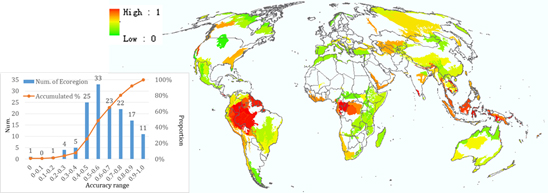
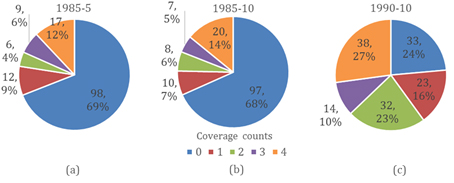
This study identified significant gaps of observation and land cover mapping of these critical terrestrial ecoregions (WWF Global 200) from space, i.e. (1) Only 18% ecoregions belong to research hotspots of land cover mapping (Figure 1); (2) Only 28 ecoregions have greater than 80% accuracy in a 30 m map, but another 36 ecoregions have poor than 50% accuracy in the same map (Figure 2); (3) The availability of Landsat TM/ETM+ data for those ecoregions is very poor (Figure 3). Therefore, data availability and accessibility remain a major challenge for the conservation community to fully utilize remote sensing techniques.
A list of possible options that may help increase historical data availability were provided in this study. Better inter-institutional coordination are needed to make existing technology and data achieves useful for conservation. In addition, pure existence of remote sensing imagery does not really always guarantee a better management in biological conservation. Remote sensing imagery and derived variables (e.g. Land cover) should be incorporated into the decision making process to achieve conservation objectives by providing a reliable, consistent and continuous measure at low cost.

Figure 1. Counts of land cover paper with study area within Global 200 ecoregions.

Figure 2. Mean accuracies of ecoregions in a land cover map.

Figure 3. Majority counts of image availability for 1985-5 (a), 1985-10 (b) and 1990-10 (c).
Reference:
Yu, L., Shi, Y., Gong, P. 2015. Land cover mapping and data availability in critical terrestrial ecoregions: A global perspective with Landsat thematic mapper and enhanced thematic mapper plus data. Biological Conservation, 190: 34-42.
http://www.sciencedirect.com/science/article/pii/S0006320715002013

